
“The technology and equipment PrecisionPoint uses [with its RapidScan service] combine laser scanning and photogrammetry in one device...The quicker turn-around time ultimately benefits the design team as well as the client.”
— Vincent Poon, Regional Principal of Design & Digital Integration, UnispacePrecisionPoint provides turnkey 3D reality capture solutions and actionable data that empower you to reliably document, design, and build.
PrecisionPoint, Inc. (PPI) has been leading the way in transforming the approach for collecting existing condition documentation since 2009. 3D laser scanning of large, complex as-built structures helps AECO* professionals accelerate the documentation process of existing conditions while improving accuracy and cutting costs. With this data, you can better evaluate, compare, and rank the environmental and financial impacts of proposed renovations in the context of real-world conditions.
*Architecture, Engineering, Construction, Operations
RapidScan + Digital Twin Viewer
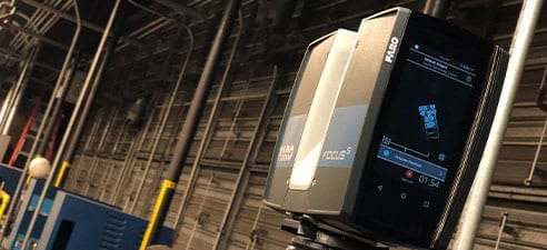
PrecisionPoint’s RapidScan captures point cloud and 360° immersive imagery at the speed of continuous walking through indoor environments. RapidScan is 30-times faster than traditional tripod-based laser scanners, mapping up to 250,000 SF per day! Whether your business is focused on AEC, facility management and operations, or manufacturing, PrecisionPoint’s RapidScan + DT Viewer solutions let us quickly, accurately, and cost-effectively create and provide access to the digital twins you need.Scan-to-BIM Solutions
PrecisionPoint’s 3D Scan-to-BIM AEC solutions capture vital as-built facility and systems data that can be imported into software applications that translate 3D point clouds into BIM software object families. By making the up-front investment in reality capture before a renovation project, you get the advantage of designing around actual building conditions and drastically reducing expensive field changes.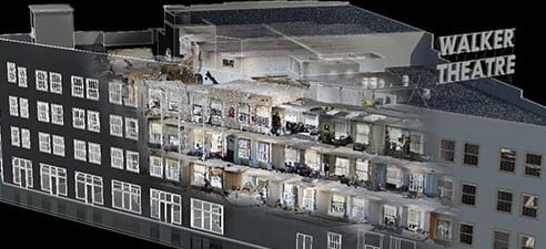
3D Laser Scanning Solutions
Though reality capture has been around for many years, it has only recently become easy enough for mainstream use in the AECO industry. The most prevalent form of reality capture is achieved through 3D laser scanning. PrecisionPoint uses 3D laser scanning devices to record digital images of your project space by rapidly capturing real world conditions and reproducing them into very precise 3D point cloud models.CORPORATE HEADQUARTERS:
12 Municipal Drive, Suite 340
Fishers, Indiana 46038
(317) 660-8620